


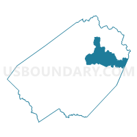
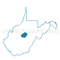
Voting District 38, Braxton County, West Virginia
About
Outline

Summary
| Unique Area Identifier | 690433 |
| Name | Voting District 38 |
| County | Braxton County |
| State | West Virginia |
| Area (square miles) | 35.56 |
| Land Area (square miles) | 35.17 |
| Water Area (square miles) | 0.39 |
| % of Land Area | 98.91 |
| % of Water Area | 1.09 |
| Latitude of the Internal Point | 38.75247300 |
| Longtitude of the Internal Point | -80.58506530 |
Maps

Graphs
Select a template below for downloading or customizing gragh for Voting District 38, Braxton County, West Virginia


Neighbors
Neighoring Voting District (by Name) Neighboring Voting District on the Map
- Voting District 1, Lewis County, WV
- Voting District 13, Braxton County, WV
- Voting District 16, Braxton County, WV
- Voting District 19, Braxton County, WV
- Voting District 24, Webster County, WV
- Voting District 36, Braxton County, WV
- Voting District 43, Braxton County, WV
- Voting District 45, Braxton County, WV
Top 10 Neighboring County Subdivision (by Population) Neighboring County Subdivision on the Map
- Courthouse-Collins Settlement district, Lewis County, WV (5,464)
- Northern district, Braxton County, WV (3,730)
- Eastern district, Braxton County, WV (3,301)
- Northern district, Webster County, WV (2,575)
Top 10 Neighboring Place (by Population) Neighboring Place on the Map
Top 10 Neighboring Unified School District (by Population) Neighboring Unified School District on the Map
- Lewis County School District, WV (16,372)
- Braxton County School District, WV (14,523)
- Webster County School District, WV (9,154)
Top 10 Neighboring State Legislative District Lower Chamber (by Population) Neighboring State Legislative District Lower Chamber on the Map
- State House District 34, WV (19,536)
- State House District 38, WV (17,592)
- State House District 36, WV (15,931)
Top 10 Neighboring State Legislative District Upper Chamber (by Population) Neighboring State Legislative District Upper Chamber on the Map
Top 10 Neighboring 111th Congressional District (by Population) Neighboring 111th Congressional District on the Map
Top 10 Neighboring Census Tract (by Population) Neighboring Census Tract on the Map
- Census Tract 9679, Braxton County, WV (5,303)
- Census Tract 9701, Webster County, WV (4,742)
- Census Tract 9676, Lewis County, WV (3,414)
Top 10 Neighboring 5-Digit ZIP Code Tabulation Area (by Population) Neighboring 5-Digit ZIP Code Tabulation Area on the Map
- 26601, WV (4,898)
- 26335, WV (1,378)
- 26621, WV (757)
- 26412, WV (546)
- 26376, WV (463)
- 26222, WV (454)
- 26627, WV (447)
- 26631, WV (352)